

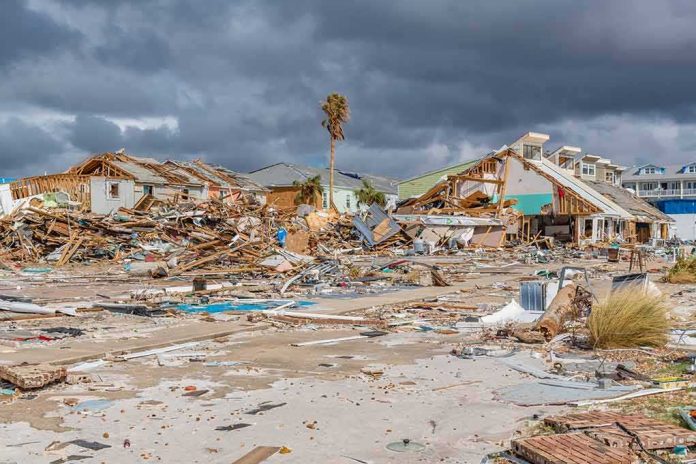
In Hawaii, the deadliest part of a tropical cyclone often arrives after the eye passes: terrain-locked rainfall stacks up, slopes fail, and lifelines like roads and power stay compromised for days. Hurricane Lala’s run at the Big Island fit that pattern precisely—extreme rain, damaging wind gusts, and cascading infrastructure problems that turned hazard warnings into lived reality.
At a Glance
- NOAA warned and then observed extreme rainfall over windward Hawai‘i Island, with maximum storm totals forecast in the 30–40 inch range.
- Strong wind gusts, especially over higher terrain, and saturated ground elevated risks of flash flooding and mudslides.
- State and county agencies faced road closures, debris, and widespread power disruptions as shelters opened and flights were canceled.
- Post-storm periods remained dangerous, with flooded areas and downed power lines posing lethal residual risk.
What Lala Did: Rain-first dynamics and vulnerable terrain
Tropical cyclones in Hawai‘i are rain machines before they are wind events. Warm Pacific moisture slams into volcanic terrain that rises from sea level to nearly 14,000 feet in under 30 miles; that orographic lift wrings storms out like a sponge. In Lala’s case, NOAA’s Central Pacific Hurricane Center (CPHC) forecast extreme rainfall, calling for maximum storm totals of 30 to 40 inches over the windward side of the Big Island, the precise geography that most efficiently converts moist flow into torrents and mud. That signal was not a headline flourish; it is the mechanism that drives Hawai‘i’s historic flash flooding, and CPHC put it plainly in multiple advisories as the storm evolved.
Wind was not incidental. Forecast discussions flagged strong gusts over higher elevations—think the saddle and summit zones above the trade-wind inversion—where the pressure gradient and terrain channeling can turn otherwise marginal boundary-layer winds into damaging bursts. CPHC highlighted those gusts and, more critically, the compound hazard that follows when wind and rain arrive together on saturated slopes: additional rounds of flash flooding and mudslides long after the worst bands appear to have passed.
The official posture: Warnings that matched the state’s risk profile
Hawai‘i Emergency Management Agency (HI-EMA) tracked Lala’s strengthening, noting when it reached Category 1 status and warning that a Big Island landfall was possible as the storm approached. The signal to residents was unambiguous: expect hurricane hazards, prepare for flash flooding, and recognize that on-island mobility could degrade rapidly as debris, high water, and landslides closed key corridors. Forecast discussions reinforced a less understood truth: the danger does not end when the center moves away. CPHC guidance explicitly cautioned residents to use care after passage because flooded areas and downed power lines remain lethal even in clearing skies—an admonition that aligns with Hawaii’s experience in past cyclone and kona low events, where post-band impacts account for a disturbing share of injuries and deaths.
Those warnings also reflected the realities of island infrastructure. The Big Island’s radial road network—Hawaii Belt Road, Mamalahoa Highway, the South Point approaches—has limited redundancy; a washout or landslide at a single choke point can isolate entire districts. During Lala, state and local outlets documented closures from flooding, debris, and slope failures on precisely those corridors. That pattern is not incidental—it is the predictable expression of topography, geology, and limited detour options under cyclone conditions.
Power and access: Why outages and closures cascade in Hawai‘i
Widespread outages during Lala were not a surprise; they were nearly guaranteed. Distribution lines in Hawai‘i are disproportionately overhead, spanning long rural runs and forested gulches. Add saturated soils that loosen tree anchorage and gusts that exceed design thresholds on exposed ridgelines, and the result is concurrent feeder trips and downed circuits across multiple districts. Live television coverage captured the operational picture as signals failed and traffic control degraded—again, a familiar hazard sequence for island storms and a reason emergency managers emphasize staying off roads unless movement is essential.
Air travel disruptions and shelter openings fit the same logic. With rapidly changing track and intensity guidance, airlines preemptively ground segments rather than strand aircraft or crews on out-islands. County agencies, reading the hydrology as much as wind risk, open shelters where flood exposure intersects with vulnerable housing stock—older single-wall construction, unanchored additions, and communities in known floodways. During Lala, the state’s mix of cancellations, sheltering, and public messaging mirrored textbook measures for a storm with high rainfall and terrain-driven flooding risk.
The track question and what counts as a “hit”
For lay readers, “landfall” is a binary—did the center cross the coastline or not? Operationally, the risk question is different: how close did the storm’s core moisture and wind fields come to the places that matter? In the 24- to 120-hour window before an event, even small errors in track and timing can be the difference between a direct eyewall scrape and a near-miss with similar rainfall and surge footprints. The scientific literature is clear that landfall probability products carry biases at different lead times and that uncertainty communication—especially on intensity near landfall—remains an active area of improvement. CPHC’s approach during Lala reflected that maturity: communicate likely hazard envelopes, especially extreme rain on windward slopes, and avoid false precision that suggests residents should relax because the centerline wobbled offshore.
Hawai‘i’s lived experience validates that framing. Island-scale mountains induce local wind maxima far from the cyclone center, and convective rain bands can lock in place on the windward coast for hours. A technical landfall determination, finalized later in a best-track archive, matters for historical records; for public safety, the operative fact was already in hand—Lala pushed a high-impact moisture plume into the Big Island and kept it there long enough to drive flash flooding, slope failures, and utility damage.
Why post-storm periods kill: Residual hazards and disciplined reentry
One of the most practical lines in CPHC’s Lala package was also the most prosaic: use caution after the storm because deadly hazards remain. Floodwaters hide eroded roadbeds and energized lines; soils on steep ground can fail without additional rain; standing water incubates disease vectors; and improvised detours lure drivers into confined valleys where another burst can trap them. That is why the restoration choreography—utility patrols before re-energizing, staged debris clearance, geotechnical checks on cuts and culverts—moves deliberately, even as residents press to return to normal. The urge to self-clear can be fatal; disciplined reentry saves lives.
There is also a data reason to slow down: accurate damage assessment is a craft. Teams cross-walk field notes with tax map keys, insurer tallies, and hydrology to determine how a structure failed—overbank flooding, mudflow, surge, or wind—and what that implies for mitigation. Hawai‘i has leveraged innovations from past events, including drone-assisted surveys and mobile platforms that allow standardized, geotagged assessments at speed. Those tools exist because the islands’ hazard profile rewards rigor over anecdotes when hardening systems for the next storm.
How Lala fits the longer arc of Hawaiian cyclone risk
Hurricane threats to Hawai‘i remain rare in the historical record, but rarity is not immunity. The islands’ topography, housing stock patterns, and infrastructure geometry create outsized consequences when a moisture-rich cyclone lingers nearby. Decades of research show forecast improvements have reduced some surprises, yet rapid intensity changes and small track errors still propagate into large differences in human outcomes—particularly evacuations, traffic loads, and power outage footprints. That is doubly true on the Big Island, where a single washed-out segment on the Belt Road can strand communities and slow emergency response by hours.
Lala’s signature—extreme forecast rainfall on windward slopes, strong high-elevation gusts, and widespread but uneven infrastructure disruption—follows this script. The takeaways are practical. First, treat rainfall guidance with the same gravity as wind categories; in Hawai‘i, inches per hour often matters more than miles per hour. Second, expect power and access issues to persist beyond the last rain band; shape personal plans accordingly. Third, let professional damage assessment work run its course; it drives everything from federal assistance triggers to the engineering choices that determine whether the same house floods again in five years.
https://twitter.com/AlmaANET25/status/2089173394617155766
What to watch as the record settles
After high-impact weather, the public record tends to sharpen over weeks: utility logs reconcile outage counts and restoration times; county and state teams quantify debris loads and structural losses; and CPHC best-track analysis finalizes intensity and track. For Lala, the most consequential through-line is already established by authoritative sources: the storm delivered the hazards emergency managers warned about—extreme rainfall on windward Hawai‘i Island, damaging gusts at elevation, flash flooding and mudslides, and dangerous post-storm conditions that demanded patience and care. The precise tally of what broke will matter for funding and mitigation, but the operational lesson is settled. In Hawai‘i, rain-driven cyclone risk remains a first-order threat, and Lala underscored why.
Sources:
thegatewaypundit.com, nhc.noaa.gov, dod.hawaii.gov, martinchockcarden.com, www2.gwu.edu, aoml.noaa.gov, iapsam.org